

Features LiPAD SIGNAGE Mobile Mapping
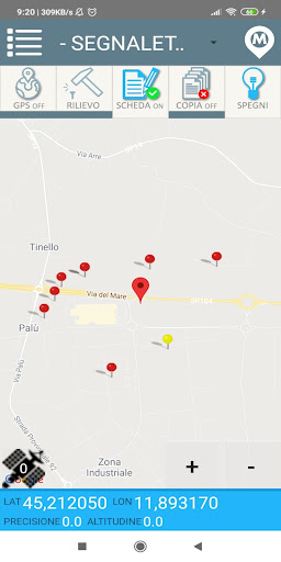
Dedicated featuresThe development of the procedure in close contact with companies active in the energy sector allows the timely scheduling of technical characteristics.Export DXF, XLS, ...Twenty-five years of development of cartographic applications allow us to communicate with the most popular GIS and technical software such as QGIS, AutoCAD and ArcGIS.- FUNCTIONALITY -CATEGORYAllows the selection of the category of elements to be mapped (bins, baskets, expired drugs, exhausted batteries, ...)MAP TYPEAllows the choice of the type of map to be represented (road, satellite, mixed).MAP AREAIt reports the portion of territory being mapped with highlighted or not highlighted objects; if necessary, it can be replaced by the compilation form, by the maintenance carried out or by the attached images.COORDINATESIt presents the current positioning values: latitude, longitude, position accuracy and detected altitude.GPSActivate the external GPS receiver (or optionally internal to the device) and the consequent interactive activity on the map area.SURVEYPressing analyzes the GPS position of the current point and fixes its position on the map.SHEETActivate or not the opening and subsequent compilation of the information sheet associated with the point previously noted.COPYActivates or not the seriality of the information associated with points detected in a row and with the same characteristics.SWITCH ONShows or hides the point elements detected in the current map portion.- AUTHORIZATIONS REQUIRED -1.
Manage phone calls: By opening the side menu of the app, our phone number is displayed for information or advice; if pressed, a call to our number is initiated.
In no other case can our application have access to its calls.2.
Multimedia contents: The light point tab gives the possibility to attach photographs taken by the device which, before being sent to the portal, are saved in the multimedia library; the application cannot view or manage other multimedia content other than those taken directly from the Li.PAD app.3.
Position: The position is used to manage the GPS of the device when viewing the map.- SPIN OFF -The high degree of customization of the service has made it possible to prepare various solutions for surveying in the field or from a fixed station and subsequent management of information on personal sites.Li.PAD Garbage - R.S.U.
Collection - bins and ecological islandsLi.PAD Covert - Technological networks, manholes and network elementsLi.PAD Signage - Road signs and / or signsLi.PAD Rainbow - Public roads, failures and bad weather damageLi.PAD Topos - Toponymy, house numbering.
Secure & Private
Your data is protected with industry-leading security protocols.
24/7 Support
Our dedicated support team is always ready to help you.
Personalization
Customize the app to match your preferences and workflow.
See the LiPAD SIGNAGE Mobile Mapping in Action


Get the App Today
Available for Android 8.0 and above